One Community

Land Purchasing and Transportation Infrastructure Due Diligence Guide
This document provides the complete research findings and official USA design standards for Land Purchasing and Transportation Infrastructure Due Diligence Considerations. It covers all transportation infrastructure requirements that must be verified before any land purchase is finalized for the One Community Global Earthbag Village project.
This document is organized into the following sections:
- What Is Land Purchasing and Transportation Infrastructure Due Diligence
- Why Is Land Purchasing Due Diligence Important for One Community?
- Legal and Title Due Diligence
- Fire Apparatus Access Standards
- Road Geometric Design Standards (AASHTO)
- Traffic Signs and Markings (MUTCD)
- Traffic Volume and Trip Generation (ITE)
- Pavement Design Standards (FHWA and AASHTO)
- ADA Accessibility Standards
- Environmental and Wetland Regulations
- Due Diligence Cost Estimates
- Conclusion
- Summary
- References/Resources
- FAQ
NOTE: THIS PAGE IS NOT CONSIDERED BY US TO BE A COMPLETE AND USABLE TUTORIAL UNTIL WE FINISH CONSTRUCTION AND ADD ALL THE VIDEOS AND EXPERIENCE FROM THE BUILD TO THIS PAGE – IN THE MEANTIME, WE WELCOME YOUR INPUT AND FEEDBACK





WHAT IS LAND PURCHASING AND TRANSPORTATION INFRASTRUCTURE DUE DILIGENCE
Land purchasing and transportation infrastructure due diligence is the process of evaluating a property’s legal status, location, accessibility, transportation connections, zoning requirements, environmental conditions, and development suitability before purchasing land. It helps identify potential risks, estimate infrastructure costs, and determine whether the property can support the intended project.
Land purchasing due diligence includes reviewing property ownership, title records, land surveys, zoning regulations, easements, utility availability, soil conditions, drainage, and environmental restrictions. Transportation infrastructure due diligence evaluates access roads, highways, public transportation, pedestrian and bicycle routes, freight access, traffic conditions, and the potential costs of building or improving transportation connections.
For sustainable community development, these assessments help ensure that land is affordable, accessible, environmentally suitable, and connected to essential services. Thorough due diligence supports informed purchasing decisions, reduces unexpected costs, and helps create safe, resilient, and well-connected communities.
WHY IS LAND PURCHASING DUE DILIGENCE IMPORTANT FOR ONE COMMUNITY?
One Community Global operates as a vehicle-free interior property designed to scale to 400+ permanent residents and 100,000+ annual visitors. Every vehicle that arrives at or departs from the property must travel the access easement road and park at the perimeter parking lot. Selecting a property that does not meet the minimum transportation infrastructure standards identified in this research can result in costly redesigns, fire code noncompliance, ADA violations, and environmental permitting delays after purchase.
This research establishes the minimum standards any candidate property must meet across six key areas before a purchase agreement is signed:
- Legal access and easement requirements
- Fire apparatus access code compliance
- Road geometric design standards
- ADA parking and accessibility compliance
- Environmental and wetland clearance
- Soil and geotechnical suitability
WAYS TO CONTRIBUTE TO EVOLVING THIS SUSTAINABILITY COMPONENT WITH US
SUGGESTIONS | CONSULTING | MEMBERSHIP | OTHER OPTIONS
CLICK THESE ICONS TO JOIN US THROUGH SOCIAL MEDIA


RESEARCHERS FOR THIS COMPONENT:
LEGAL AND TITLE DUE DILIGENCE
The following legal research establishes the minimum requirements for easement verification, zoning, and title review before any land purchase is finalized. These items must be reviewed by qualified legal counsel as part of the due diligence process.


VIDEO COMING: HOW TO COMPLETE LEGAL AND TITLE DUE DILIGENCE FOR A RURAL COMMUNITY PROPERTY PURCHASE
SEE OUR HOW TO HELP AND/OR CROWDFUNDING CAMPAIGN PAGE TO HELP CREATE ALL THE TUTORIAL VIDEOS FASTER
EASEMENT AND ACCESS VERIFICATION
 Access easement verification is the single most critical legal due diligence item for any rural property. Without a legally recorded easement that is appurtenant to the land, the property can be rendered landlocked and impossible to develop. All easement documents must be reviewed by qualified legal counsel before any purchase agreement is signed to confirm the easement is recorded, transferable, and legally permits road improvement and widening to the minimum 40 ft right-of-way required for fire apparatus access.
- A legal access easement must be recorded and appurtenant to the land meaning it runs with the property and transfers with any sale.
- The easement must legally permit road improvement, paving, and widening to the minimum 40 foot right of way required for fire apparatus access.
- Lack of a legal access easement can render a parcel landlocked, making it impossible to develop legally.
- All recorded easement documents for roads, driveways, and utility corridors must be confirmed including width and maintenance responsibilities.
- A licensed surveyor must conduct a site inspection to confirm boundaries and easement corridors.
- No weightrestricted bridges on the approach road bridges must support 75,000 lbs GVW for fire apparatus.
ZONING AND DEED RESTRICTIONS
 The following zoning and deed restriction items must be confirmed before purchase. Zoning restrictions and deed covenants that conflict with One Community’s intended use are disqualifying issues that cannot be resolved after a purchase agreement is signed identifying them before closing is the only way to avoid purchasing land that cannot legally support the planned development. A qualified real estate attorney must review all deed documents and confirm zoning compliance with the local planning authority before any offer is made.
- Confirm zoning permits the intended ecovillage and community use verify directly with local planning authority.
- Check for any deed restrictions prohibiting commercial activity, large gatherings, or visitor traffic.
- Confirm no conservation easements that restrict ground disturbance for road or parking construction.
- Verify no HOA or covenant restrictions affecting road construction or parking lot development.
- Confirm building permits can be obtained for all planned transportation infrastructure.
- Review city or county master plans and zoning updates that could affect the property’s permissible use.
FIRE APPARATUS ACCESS STANDARDS
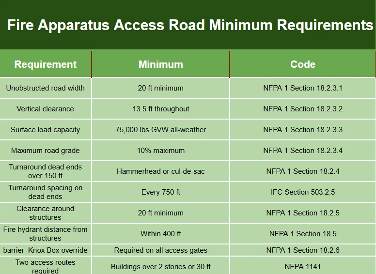
Fire apparatus access is a life safety requirement that applies to any property One Community selects. The access road must be designed and built to meet these standards before any buildings are occupied. The following sections cover the NFPA 1 Fire Code requirements that govern access road width, grade, surface loading, clearances, and turnaround design.
NFPA 1 FIRE CODE CHAPTER 18 REQUIREMENTS
NFPA 1, Fire Code, Chapter 18 establishes the minimum requirements for fire department access roads.
Click for open source spreadsheet
ROAD GEOMETRIC DESIGN STANDARDS (AASHTO)
The AASHTO Green Book A Policy on Geometric Design of Highways and Streets, 7th Edition (2018)is the primary USA standard for all access road geometric design. It is published by the American Association of State Highway and Transportation Officials and is the most widely adopted road design standard in the United States.
KEY GEOMETRIC DESIGN REQUIREMENTS
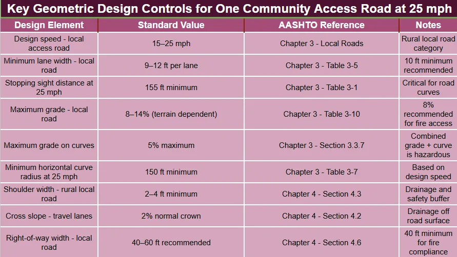
The AASHTO Green Book translates the chosen design speed into specific numeric requirements for every element of the road geometry. The following table shows the design values that apply to One Community’s access road at a 25 mph design speed, which is the appropriate speed for a rural local road of this type.
The following geometric design standards from the AASHTO Green Book apply to the One Community access road and interior road network:
Click for open source spreadsheet
TRAFFIC SIGNS AND MARKINGS (MUTCD)
The Manual on Uniform Traffic Control Devices (MUTCD), 11th Edition, published December 2023 by the Federal Highway Administration (FHWA), is the national standard for all traffic signs, road markings, and signals. The 11th Edition is the first federal MUTCD update since 2009 and became effective January 18, 2024. Revision 1 was issued December 2025.
The following MUTCD requirements apply to the One Community access road and parking lot:
- All traffic signs must meet MUTCD retroreflectivity standards for nighttime visibility
- Stop signs at road intersections minimum 30inch size for local roads (MUTCD Section 2B.04)
- Speed limit signs must be posted on all roads recommended 15 mph for interior roads
- Parking lot entrance and exit signs required (MUTCD Section 2B)
- ADA accessible parking signs must be permanently mounted minimum 60 inches above grade (MUTCD and ADA Standards)
- Pavement markings for parking stalls, drive aisles, and accessible spaces required
- No parking fire lane markings required on all fire apparatus access roads
- Directional signs required to guide vehicles from public road to parking lot entry.
TRAFFIC VOLUME AND TRIP GENERATION (ITE)
The ITE Trip Generation Manual, 12th Edition, is the authoritative USA reference for estimating vehicle traffic volumes generated by different land uses. It is published by the Institute of Transportation Engineers and is used by traffic engineers nationwide for site planning and impact analysis.
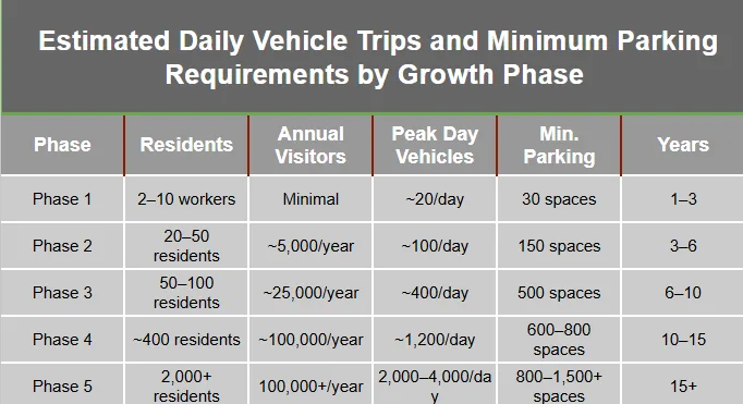
The following trip generation estimates apply to One Community Global based on ITE land use categories across growth phases:
Click for open source spreadsheet
PAVEMENT DESIGN STANDARDS (FHWA AND AASHTO)
The following pavement design standards govern the construction of the access road and parking lot surfaces. All pavement design must comply with FHWA and AASHTO standards and must be verified by a licensed geotechnical and pavement engineer before construction begins.
PAVEMENT LAYER SPECIFICATIONS
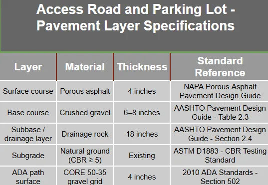
The following pavement layer specifications are carried forward from the existing Earthbag Village roadway master planand comply with FHWA and AASHTO pavement design standards:
Click for open source spreadsheet
SOIL REQUIREMENTS FOR PAVEMENT DESIGN
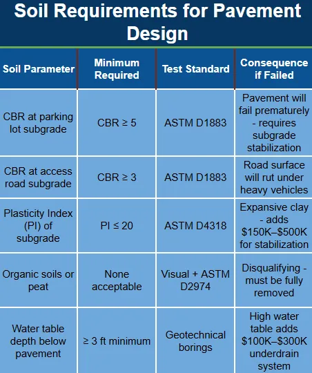
Before any pavement can be designed for the new site, the soil at the road and parking lot subgrade must be tested and confirmed to meet minimum requirements. The following table shows the soil parameters that must be confirmed through geotechnical investigation and explains what happens if any parameter fails.
The following soil requirements must be confirmed through geotechnical testing before any pavement design is finalized. These requirements are based on AASHTO and ASTM standards:
Click for open source spreadsheet
ADA ACCESSIBILITY STANDARDS
The 2010 ADA Standards for Accessible Design, published by the US Department of Justice and administered by the US Access Board, establish the minimum requirements for all parking spaces, accessible routes, ramps, and call station design. These standards are federal law and apply to all public accommodations regardless of property size.
Note: ADA stands for the Americans with Disabilities Act. The 2010 ADA Standards for Accessible Design are federal law requirements that apply to all public accommodations regardless of property size or location. For parking lots, ADA requires that accessible parking spaces and all routes connecting them to building entrances must have a surface slope no greater than 1:48 or 2.08% in any direction. This applies to the finished graded surface after construction, not the natural pre-construction slope of the land.
ACCESSIBLE PARKING SPACE REQUIREMENTS
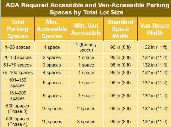
The following ADA parking requirements must be designed into the One Community parking lot from Phase 1. Requirements scale with total parking capacity as shown below:
Click for open source spreadsheet
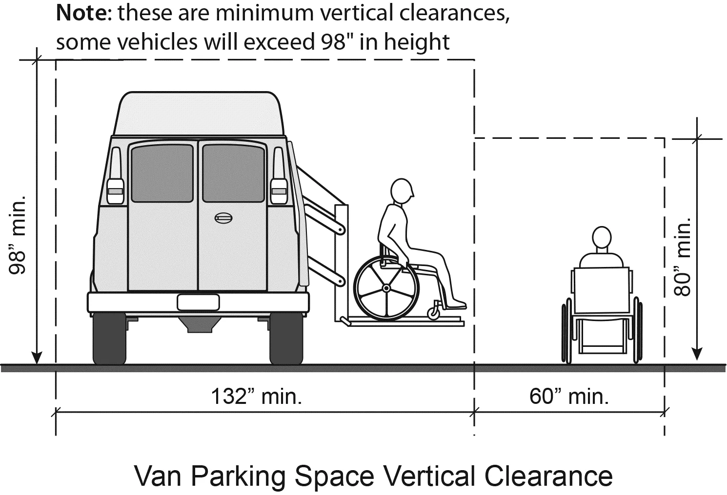
The following accessible van parking space vertical clearance diagram shows the minimum dimensions for a van-accessible parking space, including 98 inches of vertical clearance, a 132-inch minimum vehicle access aisle, and a 60-inch minimum adjacent access aisle. Wheelchair users are illustrated for accessibility reference.
ADDITIONAL ADA REQUIREMENTS
The following additional ADA requirements apply to all parking lots, access routes, and pedestrian paths:
- Maximum parking lot surface slope in any direction: 1:48 (2.08%)applies to all accessible spaces and access aisles
- Van accessible spaces require 98 inches minimum vertical clearance throughout the entire vehicular route to the space
- Access aisles must be clearly marked with diagonal striping and cannot be shared between two spaces
- Accessible parking signs must be mounted minimum 60 inches above grade so they are visible when vehicles are parked
- Each van accessible space must have additional signage reading Van Accessible below the standard accessible sign
- All accessible spaces must connect via an accessible route to the building or entrance route must be free of curbs, steps, and steep slopes
- Pedestrian path maximum running slope: 8.33% (1:12) where a ramp is provided; 5% or less on standard walking paths
- ADA path minimum width: 4 feet clear width confirmed in Earthbag Village redlines
- ADA path surface: CORE 5035 gravel grid or Gravelpave2confirmed as compliant permeable surface
ENVIRONMENTAL AND WETLAND REGULATIONS
The following environmental regulations govern land purchasing due diligence and must be verified before any purchase agreement is signed. These are official USA federal regulations administered by the US Environmental Protection Agency and the US Army Corps of Engineers.
VIDEO COMING: HOW TO BUDGET AND COMPLETE ALL PRE-PURCHASE DUE DILIGENCE INVESTIGATIONS FOR A SUSTAINABLE COMMUNITY LAND PURCHASE
SEE OUR HOW TO HELP AND/OR CROWDFUNDING CAMPAIGN PAGE TO HELP CREATE ALL THE TUTORIAL VIDEOS FASTER
CLEAN WATER ACT SECTION 404 WETLAND PROTECTION
Section 404 of the Clean Water Act (CWA) establishes the primary federal wetland protection program in the United States. The following requirements apply to any candidate property:
- A Section 404 permit is required before construction in any wetland area this includes fill for road construction, parking lot grading, and infrastructure development
- A wetland delineation survey must be completed by a qualified professional using the 1987 Army Corps Wetland Delineation Manual before purchase
- If wetlands are found in the parking lot or access road footprint, federal permitting will be required adding $200,000–$1,000,000+ to project cost or rendering the site unsuitable
- The Army Corps of Engineers issues individual permits for potentially significant wetland impacts this process can take 12–18 months
- For minimal impacts, a Nationwide Permit (NWP) may be available typically takes 45–60 days
- States may impose additional wetland protection requirements beyond federal standards
FEMA FLOOD ZONE REQUIREMENTS
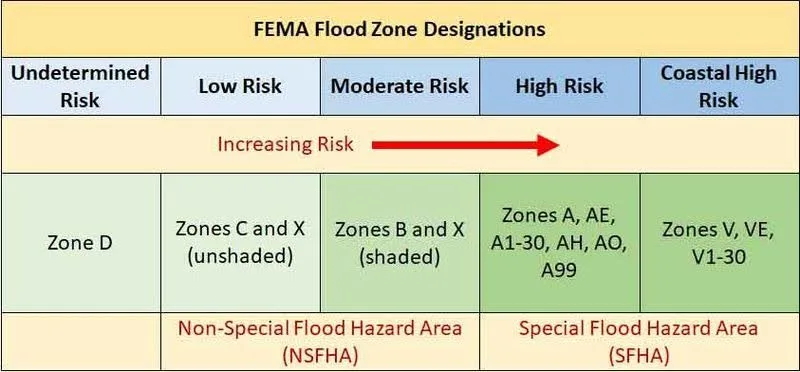
All candidate properties must be verified as not located in a FEMA Special Flood Hazard Area (SFHA) before purchase. Properties in Zone A or Zone AE flood zones are not suitable for parking lot or access road construction without extremely expensive mitigation measures that can add hundreds of thousands of dollars to the project budget. FEMA Flood Insurance Rate Maps are publicly available at no cost at msc.fema.gov and must be checked and documented as part of the due diligence file before any purchase agreement is signed.
- FEMA Flood Insurance Rate Maps (FIRM) must be checked for all candidate properties available free at msc.fema.gov
- Properties in FEMA Zone A or Zone AE (Special Flood Hazard Areas) are not suitable for parking lot or access road construction without extremely expensive flood mitigation measures
- Properties in Zone X (minimal flood hazard) or Zone X shaded (moderate flood hazard) are acceptable
- Flood zone verification must be documented and retained as part of the purchase due diligence file
- If a property is in a flood zone, a LOMA (Letter of Map Amendment) or LOMR (Letter of Map Revision) process can be pursued but this takes 3–6 months and is not guaranteed
DUE DILIGENCE COST ESTIMATES
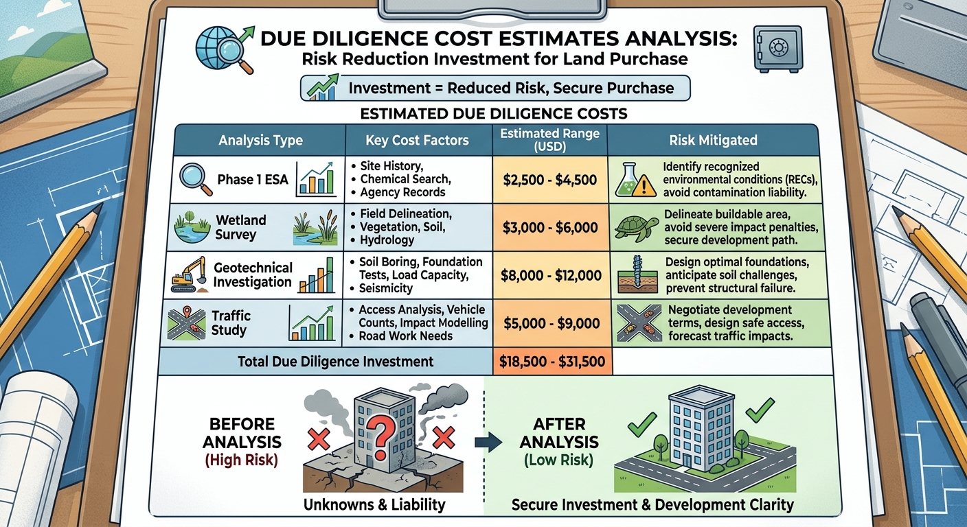
The following cost estimates are provided for budgeting all required due diligence investigations before a land purchase is finalized. These costs should be factored into the total land acquisition budget for any candidate property.
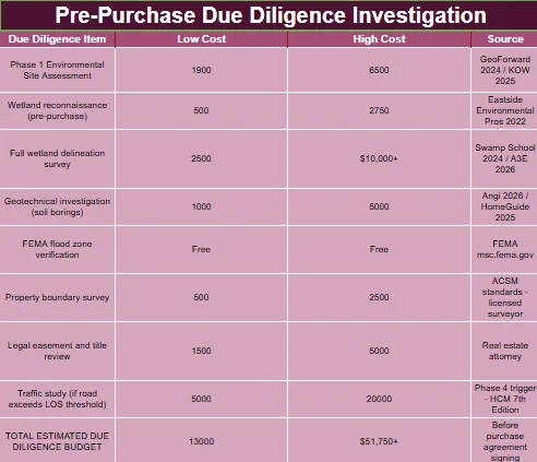
Click for open source spreadsheet
CONCLUSION
This document provides complete research findings and official USA design standards for land purchasing and transportation infrastructure due diligence for One Community Global. It is organized into nine sections covering legal research, fire access standards, road geometric design, traffic signs and markings, traffic volume estimation, pavement design, ADA accessibility, environmental and wetland regulations, and due diligence cost estimates. The detailed breakdown below summarizes what each section covers and why it matters for One Community’s property selection process.
LEGAL AND TITLE DUE DILIGENCE
Legal due diligence is the first and most fundamental step in evaluating any candidate property. Before any engineering analysis or site investigation begins, the legal framework governing the property must be confirmed. The easement and access verification subsection establishes that a legal access easement must be recorded and appurtenant to the land, meaning it runs with the property and transfers with any sale. An easement that is personal rather than appurtenant can be revoked by the granting party, rendering the property landlocked and the entire investment worthless. The easement must also legally permit road improvement, paving, and widening to the minimum 40 ft right of way required for fire apparatus access. No weightrestricted bridges can exist on the approach road since fire apparatus require a surface load capacity of 75,000 lbs gross vehicle weight. The zoning and deed restrictions subsection confirms that zoning must permit the intended ecovillage and community use before any other due diligence investment is made. Deed restrictions prohibiting commercial activity, large gatherings, or visitor traffic are disqualifying issues that cannot be overcome after purchase. Conservation easements restricting ground disturbance and HOA covenants affecting road or parking lot construction must also be identified and resolved before any purchase agreement is signed.

Legal due diligence
FIRE APPARATUS ACCESS STANDARDS
Fire apparatus access is a life safety requirement that applies to any property One Community selects, regardless of its remote or rural character. The NFPA 1 Fire Code Chapter 18 requirements establish that fire department access roads must provide 20 ft of unobstructed width, 13.5 ft of vertical clearance, a surface capable of supporting 75,000 lbs gross vehicle weight in all weather conditions, and a maximum grade of 10%. Deadend roads exceeding 150 ft in length require a turnaroundeither a hammerhead or a culdesacand the International Fire Code Section 503.2.5 requires a turnaround every 750 ft along the road’s length for longer deadend access roads. Any gate or barrier on the access road must be fitted with a Knox Box override to allow fire apparatus to pass without delay. The fire hydrant serving all structures must be within 400 ft of those structures. For One Community’s access road, which is expected to be a dead end rural road of significant length, the number of required turnarounds is directly proportional to the road’s total length; a 2.5 mile road requires approximately 17 turnarounds. This is one of the most significant cost drivers in the access road design and is a key reason why a shorter access road is strongly preferred during property selection.
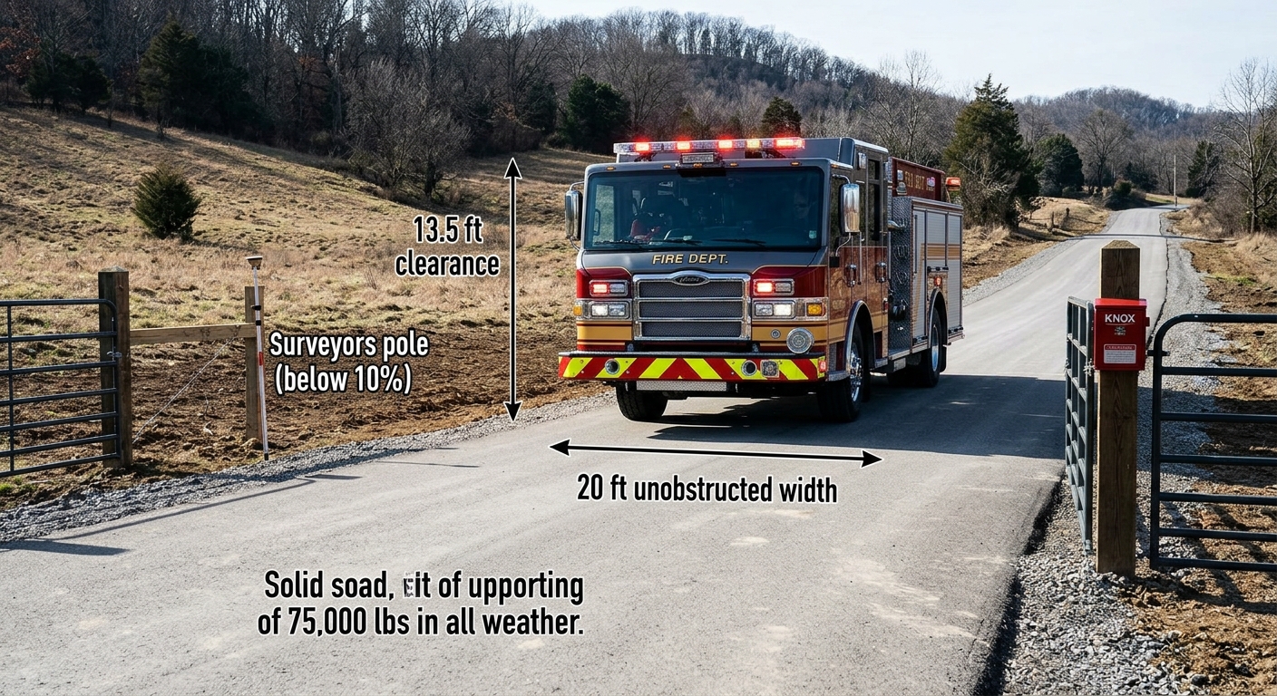
Fire Apparatus Access Standards
ROAD GEOMETRIC DESIGN STANDARDS
The AASHTO Green Book 7th Edition 2018 is the authoritative USA standard for access road geometric design. At a design speed of 25 mph, appropriate for a rural local road of One Community’s type, the Green Book establishes a minimum stopping sight distance of 155 ft, a minimum horizontal curve radius of 150 ft, a maximum sustained grade of 8%, a maximum grade through curves of 5%, and a recommended right of way width of 40 to 60 ft with 40 ft as the minimum needed to support fire apparatus compliance. The cross slope must be 2% to shed water off the travel surface toward the shoulders. These values are nonnegotiable design constants that apply to any new property regardless of terrain. If the terrain between the public road and the proposed village location cannot accommodate an 8% maximum grade road at a minimum 150 ft curve radius with 155 ft sight distance, the road alignment must be lengthened to follow a gentler path, which increases both construction cost and turnaround count. This is the connection between the geometric design standards in this section and the cost impact considerations in the due diligence cost estimates section.
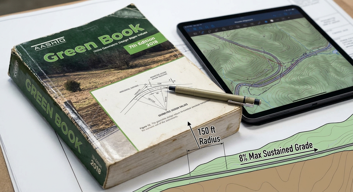
Road Geometric Design Standards
TRAFFIC SIGNS AND MARKINGS
The MUTCD 11th Edition published December 2023 with Revision 1 issued December 2025 is the federal standard governing all traffic signs, pavement markings, and traffic control devices on any road open to public travel in the United States, including private access roads. For One Community, this means all signs on the access road and in the parking lot must meet MUTCD retroreflectivity standards for nighttime visibility, stop signs at intersections must be a minimum 30inch size per MUTCD Section 2B.04, and speed limit signs must be posted on all roads. ADA accessible parking signs must be permanently mounted a minimum of 60 inches above grade per MUTCD and ADA standards, and van accessible spaces must include a secondary sign reading Van Accessible. All fire apparatus access roads must be marked as No Parking Fire Lane. These requirements are not optional, and noncompliance creates both legal liability and life safety risk during any emergency response.
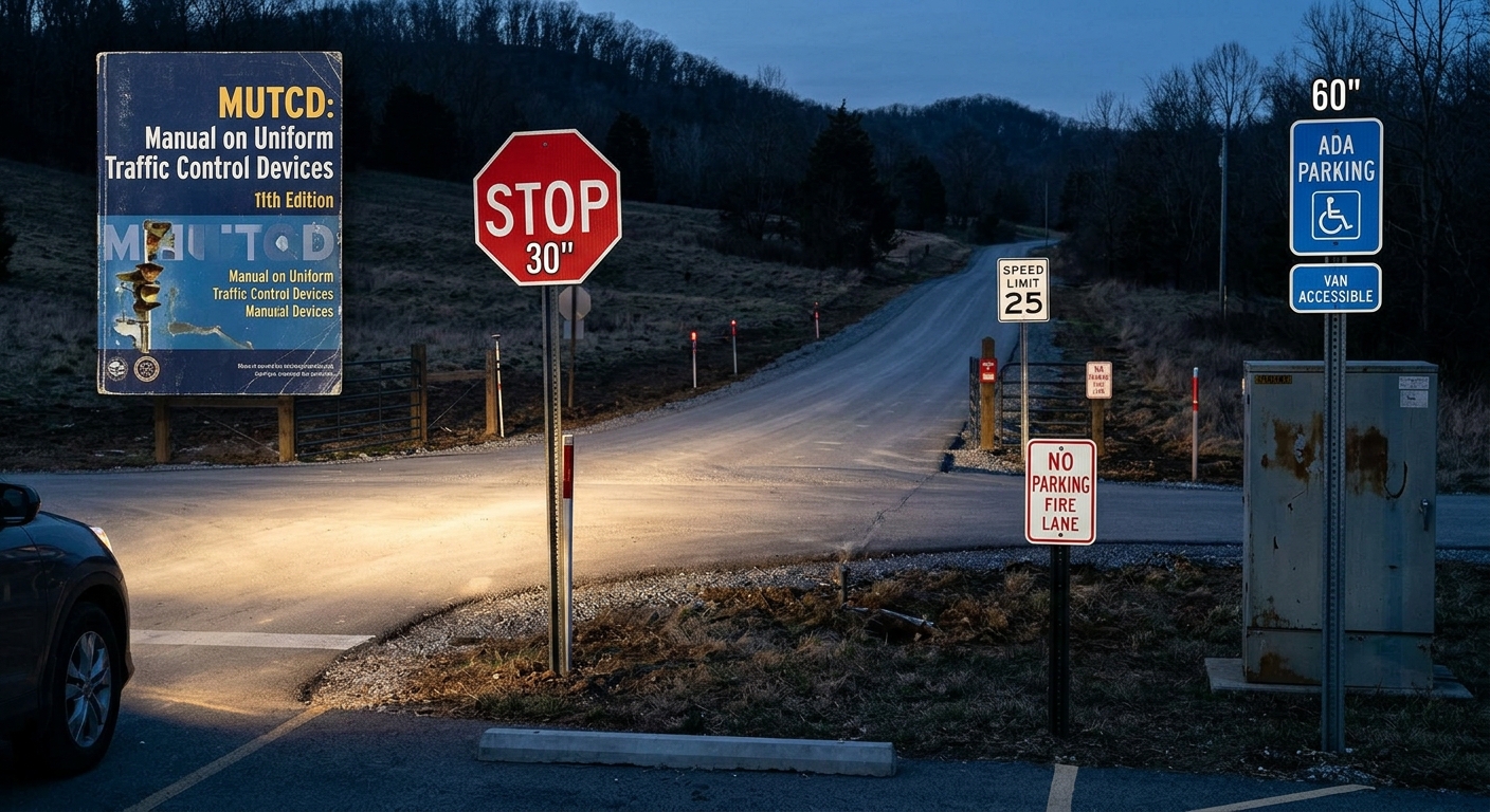
Traffic Signs and Markings
TRAFFIC VOLUME AND TRIP GENERATION
The ITE Trip Generation Manual 12th Edition 2021 is the authoritative USA reference for estimating how many vehicle trips a development will generate at each phase of growth. For One Community, trip generation determines how many vehicles the access road must handle per day at each growth phase, which in turn determines when a formal traffic study may be required by the local authority. At Phase 1 with 2 to 10 workers on site, daily vehicle trips are minimal at approximately 20 per day. By Phase 3 with 50 to 100 residents and approximately 25,000 annual visitors, daily vehicle trips approach 400. At Phase 4 with approximately 400 residents and 100,000 annual visitors, daily vehicle trips reach approximately 1,200. At this volume on a singlelane rural access road, a traffic study using HCM 7th Edition Chapter 15 may be required to confirm the road is operating at an acceptable Level of Service. This requirement should be anticipated and budgeted for during Phase 4 planning rather than triggered unexpectedly by a permit application.
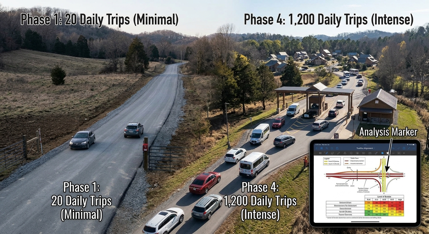
Traffic Volume and Trip Generation
PAVEMENT DESIGN STANDARDS
The AASHTO Guide for Design of Pavement Structures and FHWA pavement design publications govern the construction of One Community’s access road and parking lot surfaces. The existing Earthbag Village master plan carries forward a fourlayer pavement system consisting of a 4inch porous asphalt surface course, a 6 to 8 inch crushed gravel base course, an 18inch drainage rock subbase, and natural ground subgrade with a minimum CBR of 5. This system is designed to infiltrate rainfall directly through the pavement rather than generating surface runoff, consistent with One Community’s sustainable stormwater management approach. For this system to perform as designed, the subgrade soil at the parking lot must have a CBR of at least 5, a Plasticity Index of 20 or less confirming the absence of expansive clay, no organic soils or peat, and a water table at least 3 ft below the finished pavement surface. If any of these soil conditions cannot be confirmed through geotechnical testing before purchase, the cost of addressing them after purchase ranges from $100,000 for an underdrain system to over $500,000 for full subgrade stabilization, as documented in the cost estimates section.
Note:
CBR stands for California Bearing Ratio. It is a measurement of the strength of a soil or pavement subgrade. A higher CBR number means stronger, more stable soil. A CBR of 5 or above is the minimum required for a parking lot subgrade and a CBR of 3 or above is required for an access road subgrade. Soil below these levels will not adequately support the weight of vehicles and pavement layers over time leading to rutting cracking and eventual pavement failure. CBR testing is performed by a geotechnical engineer using ASTM D1883 standard test methods.
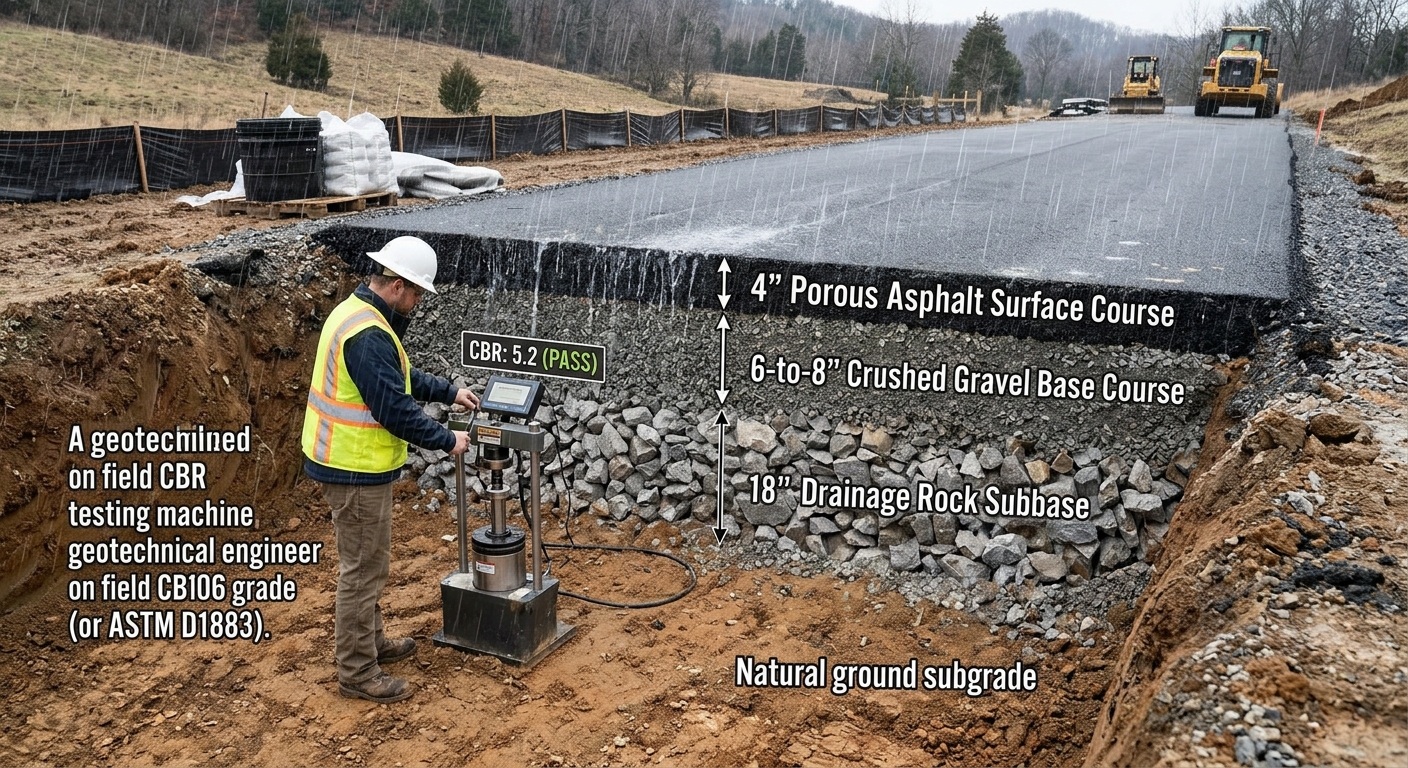
Pavement Design Standards
ADA ACCESSIBILITY STANDARDS
The 2010 ADA Standards for Accessible Design published by the US Department of Justice and administered by the US Access Board establish the minimum requirements for all parking spaces, accessible routes, ramps, and pedestrian path surfaces. These are federal law requirements that apply regardless of property size or remoteness. For One Community’s parking lot, accessible spaces must be provided at a ratio of 1 per every 25 total spaces, with van accessible spaces required at a ratio of 1 per every 6 accessible spaces. Standard accessible spaces must be at least 96 inches wide with a 60inch access aisle, and van accessible spaces must be at least 132 inches wide with a 60inch access aisle, or 96 inches wide with a 96inch access aisle. The parking lot surface slope cannot exceed 1:48 or 2.08% in any direction across all accessible spaces and access aisles. All accessible spaces must connect to the nearest building entrance via an accessible route free of curbs, steps, and slopes exceeding 8.33%. Pedestrian paths must be a minimum of 4 ft wide and the CORE 5035 gravel grid surface confirmed in the Earthbag Village redlines is a compliant permeable path surface option.
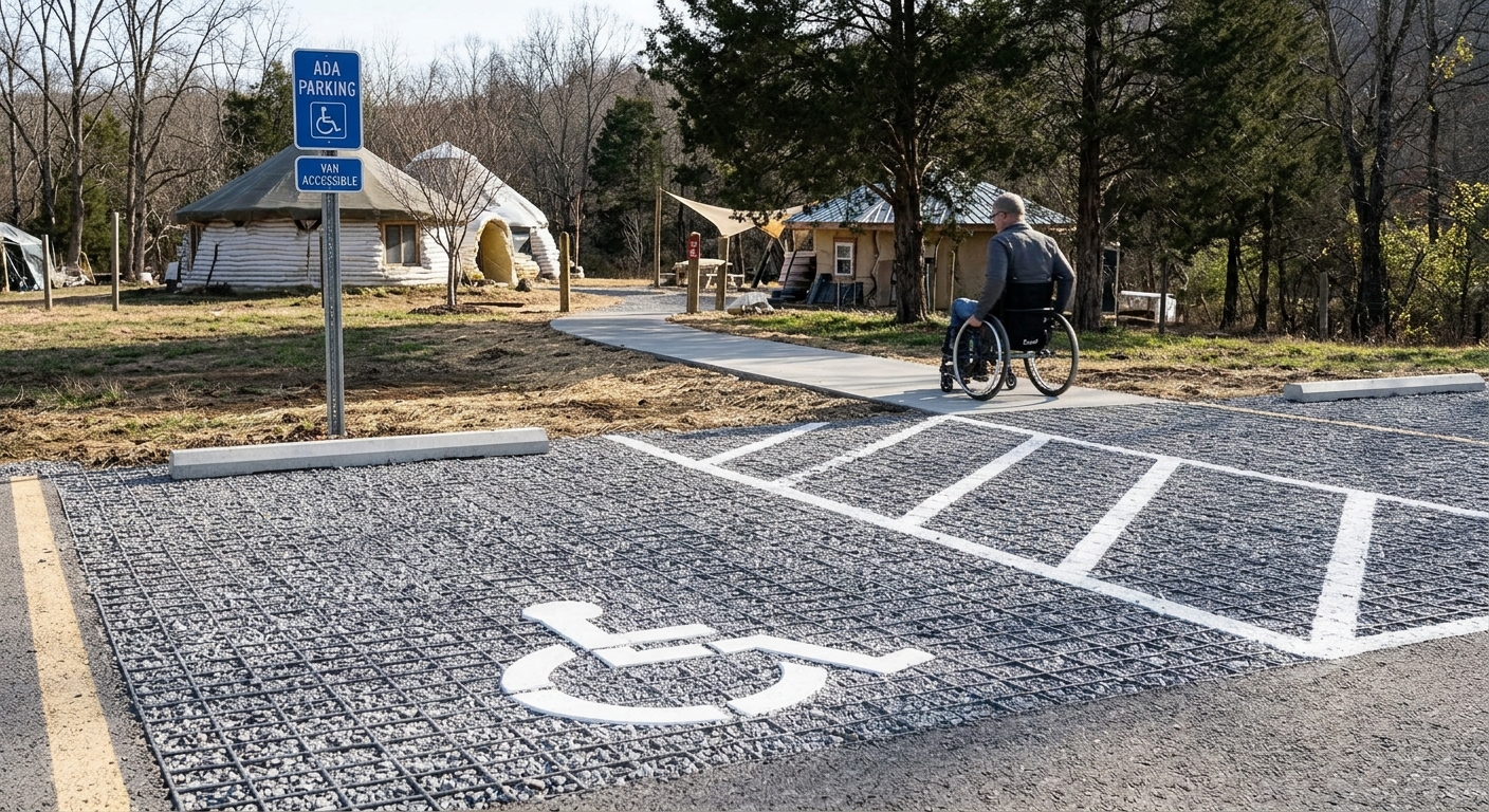
ADA Accessibility Standards
ENVIRONMENTAL AND WETLAND REGULATIONS
Section 404 of the Clean Water Act is the primary federal wetland protection regulation applicable to any candidate property One Community considers. It prohibits the discharge of dredged or fill material into waters of the United States, including wetlands, without a federal permit. For One Community, this means that any wetland found within the parking lot footprint or access road corridor triggers either a timeconsuming federal permitting process taking 12 to 18 months for an individual permit or potentially disqualifies that area of the property for construction entirely. A wetland delineation survey must be completed by a qualified professional using the 1987 Army Corps of Engineers Wetland Delineation Manual before any purchase is finalized. FEMA Flood Insurance Rate Maps must be checked for all candidate properties to confirm they are not located in FEMA Zone A or Zone AE Special Flood Hazard Areas. Properties in flood zones are not suitable for parking lot or access road construction without extremely expensive flood mitigation measures. Flood zone verification is free and available online at the FEMA Map Service Center and should be one of the first checks performed on any candidate property. An endangered species habitat survey must also confirm that no protected species critical habitat areas exist that would restrict road or parking lot construction.
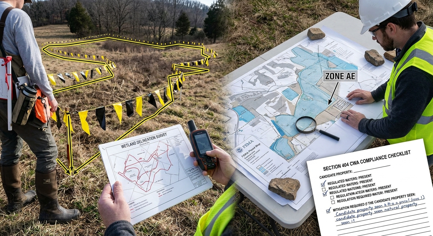
Environmental and Wetland Regulations
DUE DILIGENCE COST ESTIMATES
The total estimated budget to complete all required due diligence investigations before finalizing any land purchase ranges from $13,000 on the low end for a straightforward property to $51,750 or more for a complex property with multiple environmental or legal issues. The individual cost components are a Phase 1 Environmental Site Assessment at $1,900 to $6,500, a wetland reconnaissance prepurchase check at $500 to $2,750, a full wetland delineation survey at $2,500 to $10,000, a geotechnical soil investigation at $1,000 to $5,000, FEMA flood zone verification at no cost, a property boundary survey at $500 to $2,500, legal easement and title review at $1,500 to $5,000, and a traffic study if required at Phase 4 at $5,000 to $20,000. These costs must be viewed in context. A Phase 1 Environmental Site Assessment costing $3,000 that identifies a wetland in the parking lot footprint can prevent the purchase of a property where parking lot construction would cost $200,000 to $1,000,000 more due to Section 404 permitting or full relocation. A geotechnical investigation costing $3,000 that identifies expansive clay soils can prevent the purchase of a property where parking lot subgrade stabilization would add $150,000 to $500,000 to the construction budget. The due diligence budget is not an overhead costit is risk reduction investment that protects the entire infrastructure budget from preventable surprises after purchase.
due diligence cost estimates, land acquisition budget, land purchasing costs, property site investigations, environmental assessment costs, wetland survey costs, geotechnical investigation, soil testing costs, property boundary survey, title search costs, legal easement review, traffic study costs, FEMA flood verification, property feasibility study, land development planning, site assessment expenses, real estate due diligence, infrastructure budgeting, property risk assessment, One Community Global
SUMMARY
Land purchasing and transportation infrastructure due diligence helps One Community Global evaluate whether a property is legally suitable, environmentally appropriate, accessible, and capable of supporting planned community development. The process includes reviewing property ownership, titles, easements, zoning restrictions, fire apparatus access, road design, traffic requirements, pavement specifications, ADA accessibility, environmental conditions, and potential infrastructure costs.
Conducting these assessments before purchasing land helps identify development limitations, safety requirements, regulatory obligations, and potential expenses. By evaluating access roads, emergency vehicle circulation, traffic demand, soil conditions, drainage, wetlands, flood risks, and accessible parking and pathways, One Community can make more informed property decisions and plan infrastructure that supports safe, practical, and sustainable community development.
Thorough due diligence also helps reduce unexpected costs, avoid unsuitable properties, and identify the professional surveys, engineering assessments, environmental investigations, and legal reviews needed before acquisition. All applicable standards, design criteria, cost estimates, and regulatory requirements should be confirmed with qualified professionals and the relevant authorities for the selected property.
REFERENCES
The following references include all official USA design standards, federal regulations, and verified sources used in this research document. All web based sources have been verified as of June 2026 and backup copies should be saved to the project Dropbox folder per One Community’s documentation standards.
- A Policy on Geometric Design of Highways and Streets (Green Book), 7th EditionAmerican Association of State Highway and Transportation Officials (AASHTO), 2018Primary standard for access road geometric design. Source for minimum 40 ft right of way, 8% maximum grade, 150 ft minimum curve radius, and 155 ft stopping sight distance at 25 mph.
- Manual on Uniform Traffic Control Devices (MUTCD), 11th Edition with Revision 1Federal Highway Administration (FHWA), December 2023, Revision 1 December 2025National standard for all road signs, pavement markings, and traffic control devices. Source for stop sign sizing, speed limit sign requirements, fire lane markings, and ADA accessible parking signage
- ITE Trip Generation Manual, 12th EditionInstitute of Transportation Engineers (ITE), 2021Authoritative reference for estimating vehicle trip counts by land use type. Source for the phase by phase daily vehicle trip estimates used in the traffic volume section.
- Highway Capacity Manual (HCM), 7th Edition, Chapter 15Transportation Research Board (TRB), 2022Reference for Level of Service analysis on twolane rural highways. Applicable to the One Community access road at Phase 4 and Phase 5 buildout.
- AASHTO Guide for Design of Pavement StructuresAmerican Association of State Highway and Transportation Officials (AASHTO), 1993 with 1998 supplementSource for pavement layer thickness design using CBR values. Basis for the minimum CBR requirements in the soil requirements section.
- NFPA 1: Fire Code, Chapter 18National Fire Protection Association (NFPA), Current EditionPrimary fire code reference. Source for 20 ft minimum access road width, 13.5 ft vertical clearance, 75,000 lbs surface load capacity, 10% maximum road grade, turnaround requirements for deadend roads, and Knox Box requirements.
- International Fire Code (IFC), Section 503International Code Council (ICC), Current EditionSource for the requirement to add a turnaround every 750 ft on deadend fire apparatus access roads.
- 2010 ADA Standards for Accessible DesignU.S. Department of Justice, effective March 2012Primary accessibility reference. Source for accessible parking space minimum width of 96 inches, van accessible space minimum width of 132 inches, 1:48 maximum parking lot surface slope, 8.33% maximum ramp slope, ADA path minimum width of 4 ft, and CORE 5035 gravel grid as a compliant permeable path surface.
- Clean Water Act, Section 404U.S. Environmental Protection Agency and U.S. Army Corps of Engineers, CurrentSource for wetland delineation requirements and the 50 ft buffer requirement for all drainage discharge points near wetlands or water bodies.
- FEMA Flood Insurance Rate Maps (FIRM)Federal Emergency Management Agency (FEMA), CurrentSource for flood zone verification. All candidate properties must be confirmed as not located in FEMA Zone A or Zone AE before purchase.
- Endangered Species Act, Section 7 ConsultationU.S. Fish and Wildlife Service, CurrentSource for protected species survey requirements referenced in the environmental due diligence section.
- ASTM E152721: Standard Practice for Phase I Environmental Site AssessmentsASTM International, 2021Standard governing Phase 1 Environmental Site Assessment scope and methodology, referenced in the environmental due diligence cost estimates section.
- ASTM D1883: Standard Test Method for CBR of LaboratoryCompacted SoilsASTM International, Current EditionSource for the California Bearing Ratio testing method. CBR testing per this standard must be specified in the geotechnical investigation scope for any candidate property.
- ASTM D4318: Standard Test Methods for Liquid Limit, Plastic Limit and Plasticity Index of SoilsASTM International, Current EditionSource for Plasticity Index testing. PI of 20 or less is required at the parking lot subgrade to confirm absence of expansive clay soils.
- ASTM D2974: Standard Test Methods for Moisture, Ash and Organic Matter of PeatASTM International, Current EditionSource for organic soil and peat identification testing referenced in the geotechnical requirements section.
- Sustainable Roadways, Walkways, and Landscaping Research and DesignOne Community Global, 2019 (updated 2024)Primary organizational reference for road widths, pavement layers, fire access requirements, ADA path specifications, and drainage design standards referenced throughout this document.
FREQUENTLY ANSWERED QUESTIONS
Q: What is land purchasing and transportation infrastructure due diligence?
Land purchasing and transportation infrastructure due diligence is the process of evaluating a property’s legal status, access, zoning, environmental conditions, road requirements, and infrastructure costs before purchasing land. It helps determine whether the property is suitable for the planned development and identifies potential risks before the purchase is finalized.
Q: Why is due diligence important before purchasing land?
Due diligence helps identify ownership issues, access restrictions, zoning limitations, environmental concerns, and unexpected infrastructure expenses. For One Community, completing these assessments supports informed property selection and helps ensure the land can accommodate planned buildings, roads, parking areas, and supporting infrastructure.
Q: What legal items should be checked before purchasing land?
Review property ownership records, title documents, access easements, zoning regulations, deed restrictions, conservation easements, and applicable homeowners association covenants. These checks help identify legal conditions that could affect property access, construction, or future land use.
Q: What fire access requirements should be considered?
Fire apparatus access planning considers road width, vertical clearance, load capacity, roadway grades, turning areas, and fire hydrant accessibility. Requirements should be verified against the applicable fire code and local fire department regulations to support safe emergency vehicle access.
Q: How are road design and traffic requirements determined?
Road design and traffic evaluations consider design speed, stopping sight distance, curve geometry, roadway grades, traffic signs, pavement markings, and projected traffic volumes. Resources such as AASHTO design guidance, the MUTCD, and the ITE Trip Generation Manual can help inform planning, subject to applicable engineering standards and local requirements.
Q: Why are soil testing and pavement design important?
Soil testing helps determine whether the ground can support planned roads and parking areas. Evaluating soil stability, bearing capacity, drainage, subgrade conditions, and pavement layers helps guide material selection and reduce the risk of premature pavement failure or costly repairs.
Q: What ADA accessibility requirements should be included in site planning?
Site planning should consider accessible parking spaces, access aisles, accessible routes, ramps, pathway widths, and surface slopes. Applicable ADA standards and local building requirements should be verified to ensure that planned transportation infrastructure is accessible to people with disabilities.
Q: What environmental assessments may be needed before purchasing land?
Environmental due diligence may include wetland identification, flood-zone verification, endangered species habitat reviews, drainage evaluations, and other site investigations. These assessments help identify environmental constraints, potential permitting requirements, and conditions that could affect development feasibility.
Q: How much does land purchasing due diligence cost?
Costs depend on the property’s location, size, existing conditions, and the assessments required. Expenses may include title reviews, boundary surveys, environmental assessments, wetland delineation, geotechnical investigations, and traffic studies. Obtain project-specific estimates from qualified professionals because costs can change with market conditions and project requirements.
Q: What are common challenges in land purchasing and infrastructure planning?
Common challenges include limited project budgets, incomplete property information, changing material costs, environmental restrictions, complex regulatory requirements, and differences between preliminary designs and actual site conditions. Comparing alternatives, consulting qualified professionals, and updating cost estimates as new information becomes available can help address these challenges.
Q: Where should I start researching a property for a sustainable community?
Begin by defining the intended land use and identifying the property’s legal, environmental, transportation, and infrastructure requirements. Organize the research into key topics, consult applicable regulations and engineering guidance, and document findings, risks, and estimated costs. Update the assessment as the project develops.
Q: Where can I find additional information about One Community’s projects?
Explore One Community’s open-source resources through the One Community site map to find related information about sustainable infrastructure, community development, and other project areas.
Q: How can I share resources or suggestions to improve this page?
If you have relevant research, recommendations, or resources that could improve this content, share your suggestions through the Infrastructure and Other Collaborative Input page.